Home > Arts > Street art graffiti > Digital art > Vector illustrations
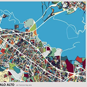
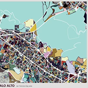
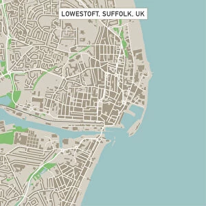
Palo Alto California US City Street Map

![]()
Wall Art and Photo Gifts from Fine Art Storehouse
Palo Alto California US City Street Map
Vector Illustration of a City Street Map of Palo Alto, California, USA. Scale 1:60, 000.
All source data is in the public domain.
U.S. Geological Survey, US Topo
Used Layers:
USGS The National Map: National Hydrography Dataset (NHD)
USGS The National Map: National Transportation Dataset (NTD)
Unleash your creativity and transform your space into a visual masterpiece!
Frank Ramspott
Media ID 15054911
© Frank Ramspott, all rights reserved
Aerial View California City Map Computer Graphic Directly Above Downtown District Gray Road Map Text Digitally Generated Image Green Color Palo Alto White Color
FEATURES IN THESE COLLECTIONS
> Aerial Photography
> Related Images
> Animals
> Insects
> Hemiptera
> Green Scale
> Animals
> Mammals
> Cricetidae
> California Mouse
> Arts
> Contemporary art
> Digital artwork
> Street art
> Arts
> Landscape paintings
> Waterfall and river artworks
> River artworks
> Arts
> Portraits
> Pop art gallery
> Street art portraits
> Arts
> Street art graffiti
> Digital art
> Digital paintings
> Arts
> Street art graffiti
> Digital art
> Vector illustrations
> Fine Art Storehouse
> Map
> Street Maps
> Fine Art Storehouse
> Map
> USA Maps
> Maps and Charts
> Geological Map
> Maps and Charts
> Related Images
EDITORS COMMENTS
This print showcases a detailed and visually stunning city street map of Palo Alto, California, USA. With a scale of 1:60,000, this vector illustration provides an intricate depiction of the downtown district, river, lake, streets, and roads that make up this vibrant city. The design is digitally generated with no people present in the image. The source data used for creating this masterpiece is in the public domain and comes from reputable sources such as the U. S. Geological Survey (USGS) - The National Map: National Hydrography Dataset (NHD) and National Transportation Dataset (NTD). These reliable datasets ensure accuracy and authenticity in capturing every aspect of Palo Alto's physical geography. In this aerial view captured directly above the cityscape, we can admire the expertly crafted cartography that highlights various elements using different colors. Shades of gray depict buildings and structures while green represents lush areas like parks or gardens. Blue signifies water bodies such as rivers or lakes while white color denotes open spaces. Designed by Frank Ramspott exclusively for Fine Art Storehouse, this visually striking print serves as both an artistic piece to adorn any wall and a functional tool for navigation enthusiasts or those curious about exploring Palo Alto's layout. It encapsulates the essence of urban life through its meticulous attention to detail and precise rendering of one of California's most beloved cities.
MADE IN THE USA
Safe Shipping with 30 Day Money Back Guarantee
FREE PERSONALISATION*
We are proud to offer a range of customisation features including Personalised Captions, Color Filters and Picture Zoom Tools
SECURE PAYMENTS
We happily accept a wide range of payment options so you can pay for the things you need in the way that is most convenient for you
* Options may vary by product and licensing agreement. Zoomed Pictures can be adjusted in the Cart.