Home > Arts > Artists > F > John Field
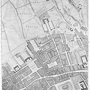
Map of Rathbone Place and its neighbourhood, Westminster, London, 1746 (1878)
")
![]()
Wall Art and Photo Gifts from Heritage Images
Map of Rathbone Place and its neighbourhood, Westminster, London, 1746 (1878)
Map of Rathbone Place and its neighbourhood, Westminster, London, 1746 (1878). From John Rocques Maps of London. John Rocque (1709-1762) created an extensive map of Georgian London in 1746. From Old and New London Illustrated, Vol IV, by Edward Walford. [Cassell Petter & Galpin, London, Paris & New York, 1878]
Heritage Images features heritage image collections
Media ID 14931639
© The Print Collector
Cartography Edward Edward Walford Georgian Map Making Marylebone Rocque Walford City Of Westminster Rathbone Place Tottenham Court
FEATURES IN THESE COLLECTIONS
> Arts
> Artists
> F
> John Field
> Arts
> Artists
> R
> John Rocque
> Arts
> Artists
> W
> John White
> Arts
> Minimalist artwork
> Monochrome artwork
> Fine art
> Arts
> Minimalist artwork
> Monochrome artwork
> Monochrome paintings
> Arts
> Portraits
> Pop art gallery
> Street art portraits
> Asia
> Georgia
> Related Images
> Europe
> France
> Paris
> Maps
> Europe
> United Kingdom
> England
> London
> Boroughs
> City of Westminster
EDITORS COMMENTS
This print takes us back in time to the bustling streets of Rathbone Place and its neighborhood in Westminster, London, during the 18th century. The detailed map, originally created by John Rocque in 1746, offers a fascinating glimpse into Georgian London's layout and architecture. As we study this monochrome masterpiece, we can't help but be drawn into the intricate cartography that showcases every lane, avenue, and street of this historic area. The print captures the essence of a bygone era when horse-drawn carriages traversed these roads and pedestrians strolled along its sidewalks. The image transports us to an enchanting world where British history comes alive. We imagine ourselves wandering through Marylebone or exploring Lambs Conduit Fields as they were centuries ago. This visual treasure is not only a testament to Rocque's skillful map-making abilities but also serves as a valuable historical document for researchers and enthusiasts alike. Edward Walford's inclusion of this remarkable print in his book "Old and New London Illustrated" further emphasizes its significance as it allows readers to delve deeper into the rich tapestry of London's past. With each line meticulously engraved on paper, this piece becomes more than just a map; it becomes an invitation to explore the hidden stories woven within Rathbone Place. Whether you are an avid historian or simply captivated by old-world charm, this print is sure to transport you back in time while igniting your curiosity about life in 18
MADE IN THE USA
Safe Shipping with 30 Day Money Back Guarantee
FREE PERSONALISATION*
We are proud to offer a range of customisation features including Personalised Captions, Color Filters and Picture Zoom Tools
SECURE PAYMENTS
We happily accept a wide range of payment options so you can pay for the things you need in the way that is most convenient for you
* Options may vary by product and licensing agreement. Zoomed Pictures can be adjusted in the Cart.