Home > Europe > Italy > Campania > Naples
Panoramic map of Mediterranean by G. H. Davis

![]()
Wall Art and Photo Gifts from Mary Evans Picture Library
Panoramic map of Mediterranean by G. H. Davis
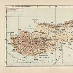
A new centre of world alarm during the Second World War: a panoramic map of the Mediterranean, showing the principal bases. The framework of strategy in the Mediterranean: Gibraltar, Toulon, Naples, Malta and Alexandria -- names that have figured in so many wars in the past -- are again being discussed all over the world. This map also shows new key points, such as Rhodes, Izmit and Haifa.
1940
Mary Evans Picture Library makes available wonderful images created for people to enjoy over the centuries
Media ID 14133017
© Illustrated London News Ltd/Mary Evans
Alarm Alexandria Bases Cyprus Davis Framework Gibraltar Haifa Izmit Malta Mediterranean Naples Panoramic Points Principal Rhodes Strategy Toulon Wars
FEATURES IN THESE COLLECTIONS
> Africa
> Related Images
> Asia
> Cyprus
> Related Images
> Asia
> Turkey
> Related Images
> Europe
> France
> Canton
> Landes
> Europe
> Italy
> Campania
> Naples
> Europe
> Malta
> Related Images
> Europe
> Related Images
A New Centre of World Alarm During the Second World War - A Panoramic Map of the Mediterranean, Showing the Principal Bases
EDITORS COMMENTS
This evocative panoramic map, created by G.H. Davis in 1940, offers a compelling glimpse into the strategic importance of the Mediterranean during the early stages of the Second World War. The map serves as a testament to the enduring significance of this body of water, which has long been a focal point of European and African history and a nexus of geopolitical intrigue. At the heart of the map lie the names that have figured in so many wars throughout history: Gibraltar, Toulon, Naples, Malta, and Alexandria. These key locations, which have shaped the course of European and African history for centuries, were once again at the forefront of global discussions as the world braced for the challenges of the Second World War. But this map also highlights new strategic points of importance, such as Rhodes, Izmit, and Haifa. These emerging key locations underscore the dynamic nature of the Mediterranean theatre of war and the ever-evolving geopolitical landscape of the region. The Mediterranean, with its European and African coasts, has long been a critical link between the Middle East and Europe. As the map reveals, the region's strategic importance was not lost on the world's military and political leaders during the Second World War. The Mediterranean's North African and Eastern European coasts, in particular, were hotly contested, with control of these areas often determining the outcome of major campaigns. This panoramic map, produced by G.H. Davis in 1940, offers a unique perspective on the Mediterranean during a pivotal moment in world history. It serves as a reminder of the enduring significance of this body of water and the strategic importance of the regions that surround it.
MADE IN THE USA
Safe Shipping with 30 Day Money Back Guarantee
FREE PERSONALISATION*
We are proud to offer a range of customisation features including Personalised Captions, Color Filters and Picture Zoom Tools
SECURE PAYMENTS
We happily accept a wide range of payment options so you can pay for the things you need in the way that is most convenient for you
* Options may vary by product and licensing agreement. Zoomed Pictures can be adjusted in the Cart.