Home > Europe > United Kingdom > England > Yorkshire > Sheffield
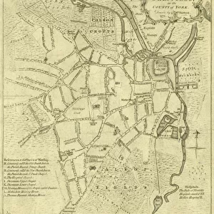
Plan of part of the west side of the township of Sheffield, 1829

![]()
Wall Art and Photo Gifts from Sheffield City Archives
Plan of part of the west side of the township of Sheffield, 1829
Full title: Plan of part of the west side of the township of Sheffield shewing the parts of Nether Hallam and Ecclesall Bierlow intermixed therewith and adjoining upon it.
Taken for the Surveyors of the Highways of the township of Sheffield and describes the ancient boundaries of the several townships which are coloured as hereunder described - the lands of the Sheffield township - green, Nether Hallam - red, and Ecclesall Bierlow - yellow.
Shows Broad Lane, Leavy Greave Lane, Glossop Road, Portobello, Wilkinson Street, Gell Street and Hawke Street; also shows Leavy Greave [property] and a reservoir.
Dimensions of original approx. 85 x 63 cm.
From an original at Sheffield Libraries: arc04048
Sheffield City Archives and Local Studies Library has an unrivalled collection of images of Sheffield, England
Media ID 23122569
© Sheffield City Council - All Rights Reserved
FEATURES IN THESE COLLECTIONS
> Europe
> United Kingdom
> England
> West Yorkshire
> Related Images
> Europe
> United Kingdom
> England
> Yorkshire
> Related Images
> Europe
> United Kingdom
> England
> Yorkshire
> Sheffield
> Europe
> United Kingdom
> England
> Yorkshire
> Street
> Maps and Charts
> Early Maps
> Maps and Charts
> Related Images
> Sheffield City Archives
> Maps and Plans
> Maps of Sheffield
EDITORS COMMENTS
This print showcases a historical map titled "Plan of part of the west side of the township of Sheffield, 1829". The detailed illustration provides a fascinating glimpse into the past, specifically highlighting Nether Hallam and Ecclesall Bierlow townships intertwined with Sheffield. Commissioned by the Surveyors of the Highways in Sheffield, this map accurately depicts ancient boundaries using distinct colors to differentiate each township: green for Sheffield, red for Nether Hallam, and yellow for Ecclesall Bierlow. Notable landmarks such as Broad Lane, Leavy Greave Lane, Glossop Road, Portobello, Wilkinson Street, Gell Street, and Hawke Street are clearly marked on this comprehensive plan. The inclusion of Leavy Greave property and a reservoir adds further intrigue to this historical document. With dimensions approximating 85 x 63 cm. , it is evident that great care was taken in creating this intricate map. Preserved within Sheffield Libraries' archives (arc04048), this invaluable piece offers an opportunity to explore Yorkshire's rich history through cartography. It is important to note that while sharing information about this remarkable artifact from Sheffield City Archives is encouraged; any commercial use or association with a specific company should not be mentioned or implied.
MADE IN THE USA
Safe Shipping with 30 Day Money Back Guarantee
FREE PERSONALISATION*
We are proud to offer a range of customisation features including Personalised Captions, Color Filters and Picture Zoom Tools
SECURE PAYMENTS
We happily accept a wide range of payment options so you can pay for the things you need in the way that is most convenient for you
* Options may vary by product and licensing agreement. Zoomed Pictures can be adjusted in the Cart.