Home > Aerial Photography > Related Images
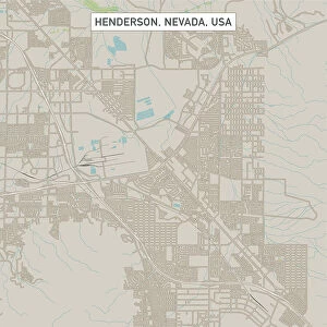
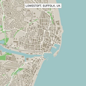
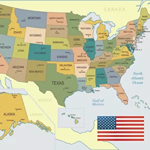
Arvada Colorado US City Street Map

![]()
Wall Art and Photo Gifts from Fine Art Storehouse
Arvada Colorado US City Street Map
Vector Illustration of a City Street Map of Arvada, Colorado, USA. Scale 1:60, 000.
All source data is in the public domain.
U.S. Geological Survey, US Topo
Used Layers:
USGS The National Map: National Hydrography Dataset (NHD)
USGS The National Map: National Transportation Dataset (NTD)
Unleash your creativity and transform your space into a visual masterpiece!
Frank Ramspott
Media ID 15215846
© Frank Ramspott, all rights reserved
Aerial View City Map Colorado Computer Graphic Directly Above Downtown District Gray Road Map Text Digitally Generated Image Green Color White Color
FEATURES IN THESE COLLECTIONS
> Aerial Photography
> Related Images
> Animals
> Insects
> Hemiptera
> Green Scale
> Arts
> Contemporary art
> Digital artwork
> Street art
> Arts
> Landscape paintings
> Waterfall and river artworks
> River artworks
> Arts
> Portraits
> Pop art gallery
> Street art portraits
> Arts
> Street art graffiti
> Digital art
> Digital paintings
> Arts
> Street art graffiti
> Digital art
> Vector illustrations
> Fine Art Storehouse
> Map
> Street Maps
> Fine Art Storehouse
> Map
> USA Maps
> Maps and Charts
> Geological Map
> Maps and Charts
> Related Images
> North America
> United States of America
> Colorado
> Related Images
EDITORS COMMENTS
This print showcases a meticulously detailed vector illustration of the charming city street map of Arvada, Colorado, USA. With a scale of 1:60,000, every intricate aspect is brought to life in this visually stunning piece. The source data used for this artwork is all from the public domain, specifically obtained from the U. S. Geological Survey and US Topo. The various layers utilized include the USGS National Hydrography Dataset (NHD) and the USGS National Transportation Dataset (NTD), ensuring accuracy and precision in depicting the city's hydrography and transportation networks respectively. Featuring Arvada's downtown district, lakes, rivers, streets, roads, and overall city layout - this map art encapsulates both functionality and aesthetic appeal. Digitally generated with impeccable design techniques by Frank Ramspott; it flawlessly captures the essence of Arvada's physical geography. With no people present in this aerial view taken directly above the cityscape; shades of gray blend harmoniously with blue skies while pops of white color highlight roadways. Green hues symbolize lush areas while text elements provide additional context. Perfect for admirers of cartography or those seeking a unique decorative touch for their space; this print offers an engaging glimpse into Arvada's urban landscape that will surely captivate any observer.
MADE IN THE USA
Safe Shipping with 30 Day Money Back Guarantee
FREE PERSONALISATION*
We are proud to offer a range of customisation features including Personalised Captions, Color Filters and Picture Zoom Tools
SECURE PAYMENTS
We happily accept a wide range of payment options so you can pay for the things you need in the way that is most convenient for you
* Options may vary by product and licensing agreement. Zoomed Pictures can be adjusted in the Cart.