Home > Sheffield City Archives > Maps and Plans > Maps of Sheffield
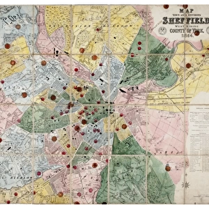
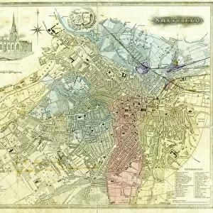
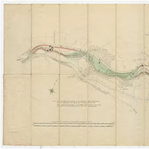
Plan of part of the townships of Sheffield and Nether Hallam, Sheffield, c. 1826

![]()
Wall Art and Photo Gifts from Sheffield City Archives
Plan of part of the townships of Sheffield and Nether Hallam, Sheffield, c. 1826
Full title: Plan of part of the townships of Sheffield and Nether Hallam which is in dispute.
Includes John Addys house, Lidgate Field, Shales Moor Close, White House Lane or Walkley Road, Penistone Turnpike Road, old road from Owlerton to Sheffield, Green lane, Cleakham [Cleakum Inn], Morton Wheel and Morton Wheel Dam, River Dun and Bacons Island, waterworks, poor house, Bellefield House, Daniel hill, infirmary, Philadelphia, West Dun, Hillsborough Barracks, Bowling Green, a tavern [possibley the Cambridge public house], St Philips Church, Globe Works, Roscoe Place, Hoyle Street, Dun Street, Moor Fields, Green Lane, etc.
Dimensions: approx. 69 x 49 cm.
From an original at Sheffield Libraries: arc03896
Sheffield City Archives and Local Studies Library has an unrivalled collection of images of Sheffield, England
Media ID 19827424
© Sheffield City Council - All Rights Reserved
Fairbank Hillsborough Netherthorpe River Don Sheffield Upperthorpe Yorkshire Green Lane Hoyle Street Infirmary Road Moorfields Penistone Road Royal Infirmary St Philips Road Water Mills Water Power Waterworks Workhouses
EDITORS COMMENTS
This print showcases a detailed "Plan of part of the townships of Sheffield and Nether Hallam" dating back to approximately 1826. The plan, which is in dispute, offers a fascinating glimpse into the historical landscape of Sheffield during that era. Spanning an impressive size of around 69 x 49 cm, this archival piece provides a wealth of information about various landmarks and locations within the townships. Highlighted on the plan are notable places such as John Addys house, Lidgate Field, Shales Moor Close, White House Lane (also known as Walkley Road), Penistone Turnpike Road, Owlerton to Sheffield old road, Green lane, Cleakham Inn (Cleakum Inn), Morton Wheel and Morton Wheel Dam. Additionally featured are significant elements like River Dun and Bacons Island, waterworks infrastructure, poor house facilities, Bellefield House residence, infirmary buildings including Philadelphia and West Dun sections. Other prominent sites depicted include Hillsborough Barracks along with Bowling Green recreational area. Furthermore St Philips Church stands out prominently alongside Globe Works factory complex while Roscoe Place intersects Hoyle Street and Dun Street in close proximity to Moor Fields. This remarkable print from Sheffield Libraries' collection at arc03896 not only preserves crucial historical details but also sheds light on lesser-known aspects such as workhouses in Watery Street or St Philips Road's connection to Daniel Hill. While exploring this image transports us back centuries ago it is important to note that commercial use should not be associated with it.
MADE IN THE USA
Safe Shipping with 30 Day Money Back Guarantee
FREE PERSONALISATION*
We are proud to offer a range of customisation features including Personalised Captions, Color Filters and Picture Zoom Tools
SECURE PAYMENTS
We happily accept a wide range of payment options so you can pay for the things you need in the way that is most convenient for you
* Options may vary by product and licensing agreement. Zoomed Pictures can be adjusted in the Cart.