Home > Europe > United Kingdom > Scotland > Edinburgh > Edinburgh
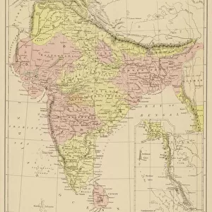
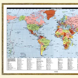
Map of the Indian Ocean, 1902. Creator: Unknown

![]()
Wall Art and Photo Gifts from Heritage Images
Map of the Indian Ocean, 1902. Creator: Unknown
Map of the Indian Ocean, 1902. Showing the coast of East Africa, Arabia, the Indian subcontinent, the Far East and part of Australia. From The Century Atlas of the World. [John Walker & Co, Ltd. London, 1902]
Heritage Images features heritage image collections
Media ID 15512808
© The Print Collector / Heritage-Images
Arabia Australia Cartography Edinburgh Geographical Institute Far East Indian Ocean Map Making Hindoostan Mercator Projection
FEATURES IN THESE COLLECTIONS
> Arts
> Artists
> O
> Oceanic Oceanic
> Asia
> India
> Related Images
> Europe
> United Kingdom
> Scotland
> Edinburgh
> Edinburgh
> Europe
> United Kingdom
> Scotland
> Lothian
> Edinburgh
> Maps and Charts
> India
> Maps and Charts
> Related Images
> Maps and Charts
> World
EDITORS COMMENTS
This print showcases a remarkable piece of cartographic history - the "Map of the Indian Ocean, 1902". Created by an unknown artist, this map offers a fascinating glimpse into the world as it was over a century ago. Spanning across East Africa, Arabia, the Indian subcontinent, the Far East, and even part of Australia, this meticulously detailed map provides valuable insights into the geographical features and locations that defined these regions during that time. The vibrant colors used in this print bring life to each country and continent depicted on its surface. The map's creator employed a Mercator projection technique to accurately represent these vast territories surrounding one of Earth's most significant bodies of water - the Indian Ocean. This particular edition originates from The Century Atlas of the World published by John Walker & Co. , Ltd. in London. As we marvel at this historical artifact produced by Edinburgh Geographical Institute in collaboration with The Print Collector, we are reminded not only of our ever-changing world but also how crucial maps have been throughout history for exploration and navigation purposes. Whether studying geography or simply appreciating artistry within cartography, this stunning image serves as a testament to human curiosity about our planet's diverse landscapes and cultures.
MADE IN THE USA
Safe Shipping with 30 Day Money Back Guarantee
FREE PERSONALISATION*
We are proud to offer a range of customisation features including Personalised Captions, Color Filters and Picture Zoom Tools
SECURE PAYMENTS
We happily accept a wide range of payment options so you can pay for the things you need in the way that is most convenient for you
* Options may vary by product and licensing agreement. Zoomed Pictures can be adjusted in the Cart.