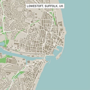
Home > Europe > United Kingdom > England > Norfolk > Thetford
Thetford Norfolk UK City Street Map

![]()
Wall Art and Photo Gifts from Fine Art Storehouse
Thetford Norfolk UK City Street Map
Vector Illustration of a City Street Map of Thetford, Norfolk, UK. Included files are EPS (v10) and Hi-Res JPG.
Data courtesy from Ordnance Survey: VectorMap District
https:/ordnancesurvey.co.uk/business-and-government/products/vectormap-district.html
OS OpenData is free to use under the Open Government Licence (OGL).
Contains OS data eCrown copyright and database right 2017.
http:/nationalarchives.gov.uk/doc/open-government-licence/version/3/
Unleash your creativity and transform your space into a visual masterpiece!
Frank Ramspott
Media ID 15055259
© Frank Ramspott, all rights reserved
Aerial View Computer Graphic Directly Above Gray Green Norfolk Road Map Street Map Text Digitally Generated Image Thetford
FEATURES IN THESE COLLECTIONS
> Aerial Photography
> Related Images
> Arts
> Contemporary art
> Digital artwork
> Street art
> Arts
> Landscape paintings
> Forest and woodland scenes
> Forest artwork
> Arts
> Landscape paintings
> Waterfall and river artworks
> River artworks
> Arts
> Portraits
> Pop art gallery
> Street art portraits
> Arts
> Street art graffiti
> Digital art
> Digital paintings
> Arts
> Street art graffiti
> Digital art
> Vector illustrations
> Europe
> United Kingdom
> England
> Norfolk
> Related Images
> Europe
> United Kingdom
> England
> Norfolk
> Thetford
> Europe
> United Kingdom
> Maps
> Fine Art Storehouse
> Map
> Street Maps
EDITORS COMMENTS
This print showcases a detailed and intricate city street map of Thetford, Norfolk, UK. The vector illustration beautifully captures the essence of this charming town, highlighting its key features such as Thetford Forest and the meandering River Little Ouse. The map is meticulously designed using EPS (v10) and Hi-Res JPG files, ensuring high-quality resolution for an immersive viewing experience. Data courtesy from Ordnance Survey's VectorMap District adds credibility to the accuracy of this representation. Thetford's rich history and vibrant streets come alive in this digitally generated image. With no people present, the focus remains solely on the city's layout and architecture. The color palette blends shades of gray with pops of green and blue against a clean white background, creating a visually striking aesthetic. This aerial view provides a unique perspective directly above Thetford, allowing viewers to appreciate its urban planning and cartography at large scale. The inclusion of text enhances navigational clarity while maintaining an artistic touch. Frank Ramspott skillfully brings together elements of physical geography and computer graphics to produce this exceptional piece that would be ideal for any home or office space. Whether you're a resident or simply captivated by maps, this print offers both functional value and aesthetic appeal that will surely impress all who lay eyes upon it.
MADE IN THE USA
Safe Shipping with 30 Day Money Back Guarantee
FREE PERSONALISATION*
We are proud to offer a range of customisation features including Personalised Captions, Color Filters and Picture Zoom Tools
SECURE PAYMENTS
We happily accept a wide range of payment options so you can pay for the things you need in the way that is most convenient for you
* Options may vary by product and licensing agreement. Zoomed Pictures can be adjusted in the Cart.