Home > Europe > United Kingdom > England > London > Boroughs > Hackney
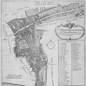
Map of Victoria Park

![]()
Wall Art and Photo Gifts from Mary Evans Picture Library
Map of Victoria Park
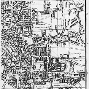
The proprosed plan of Victoria Park, Bethnal Green. The entire tract of land lying between the Hackney and Whitechapel roads contains about 290 acres
Mary Evans Picture Library makes available wonderful images created for people to enjoy over the centuries
Media ID 4465391
© Mary Evans Picture Library 2015 - https://copyrighthub.org/s0/hub1/creation/maryevans/MaryEvansPictureID/10416262
FEATURES IN THESE COLLECTIONS
> Europe
> France
> Canton
> Landes
> Europe
> United Kingdom
> England
> London
> Boroughs
> Hackney
> Europe
> United Kingdom
> England
> London
> Sights
> Victoria Park
> Maps and Charts
> Early Maps
> Maps and Charts
> Related Images
EDITORS COMMENTS
1. Title: "Victoria Park: A Historical Exploration of the Proposed Plan, 1843" This map print, sourced from Mary Evans Prints Online, offers a fascinating glimpse into the proposed plan for Victoria Park in Bethnal Green, London, as it was envisioned in 1843. Covering approximately 290 acres of land, the park lies nestled between the Hackney and Whitechapel roads. The map reveals the meticulously planned layout of this public green space, which was designed to provide much-needed respite and recreation for the growing urban population of East London. The intricate details showcase the various features that were intended to make Victoria Park a unique and enjoyable destination. At the heart of the park, a large lake is depicted, surrounded by picturesque walks, ornamental gardens, and a bandstand. The park's boundaries are marked by grand entrance gates, ensuring a sense of exclusivity and order. The map also reveals the strategic placement of various facilities, such as a cricket ground, tennis courts, and a rifle range, catering to a diverse range of recreational interests. The history of Victoria Park is rooted in the social and cultural context of the time. The park was one of the first public parks in London, and its creation was a response to the growing awareness of the importance of providing open spaces for the urban population. The park's design was influenced by the Picturesque Movement, which emphasized the beauty and tranquility of nature, and the desire to create a space that would bring people together and promote community cohesion. This map print serves as a testament to the vision and foresight of those who championed the creation of Victoria Park, and offers a glimpse into the rich history and heritage of this beloved London landmark.
MADE IN THE USA
Safe Shipping with 30 Day Money Back Guarantee
FREE PERSONALISATION*
We are proud to offer a range of customisation features including Personalised Captions, Color Filters and Picture Zoom Tools
SECURE PAYMENTS
We happily accept a wide range of payment options so you can pay for the things you need in the way that is most convenient for you
* Options may vary by product and licensing agreement. Zoomed Pictures can be adjusted in the Cart.